Internet in Bolivia is crap. Thus while we search for someplace with stronger internet to upload the vids, we leave you with a few photos and 1000 words.
La première image qui me venait en tête en pensant au Pérou était un petit
village dans les hauteurs des Andes avec des amérindiennes en costumes
traditionnelles et les hommes mâchant des feuilles de coca et certainement pas des kilomètres et des kilomètres de désert .
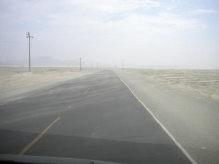
Parce que la côte péruvienne c’est bien cela, du sable à perte de vue…
The first thoughts of Peru may be some lost village stuck in the mountians, with a bunch of indigenous folks, traditionally garbed, huddled around a llama-poo fire, with cheeks all puffed out from gnawing on coca leaves; not some endless horizon of desert and blowing sand. So this is what we found...
The first thoughts of Peru may be some lost village stuck in the mountians, with a bunch of indigenous folks, traditionally garbed, huddled around a llama-poo fire, with cheeks all puffed out from gnawing on coca leaves; not some endless horizon of desert and blowing sand. So this is what we found...
Nous sommes
arrivés par le nord bien sûr et c’est
à Zorritos que nous avons fait connaissance avec cette race de chien typique du
Pérou qui n’a pas de poils dont la température corporelle est plus haute que
les autres races et qui était traditionnellement utilisé comme « bouillote »
pour les gens avec de l’arthrite!
Coming into Peru from the north, we bumped into this hairy bastard in Zorritos. Sadly this bald pooch has more HAIR on him than I got on my head. Seems that these doggies sport no hair and a body temperature higher than normal (see the connection?) and is otherwise substitute for a hot-water bottle for the arthritic. Or your granny.
Coming into Peru from the north, we bumped into this hairy bastard in Zorritos. Sadly this bald pooch has more HAIR on him than I got on my head. Seems that these doggies sport no hair and a body temperature higher than normal (see the connection?) and is otherwise substitute for a hot-water bottle for the arthritic. Or your granny.

Nous avons
continué notre route jusqu’à Mancora, petite ville balnéaire, réputé pour le surf,
hyper touristique et pas dans le bon sens du terme. Nous y sommes restés quelques jours pour y
faire des affaires et çà a bien fonctionné puisque nous avons vendu la planche
de surf de Chris et notre vélo pliable. Le tout très rapidement, les péruviens
adorent la marchandise d’Amérique du nord alors il a suffit de dire que la
planche venait de Californie et le vélo du Canada (ce qui était vrai) et le
tour était joué!
We continued tracking southward to Mancora, a small fishing village, reputed for surfing. Turns out just a gringo slum sort of inner city 'projects' kind of feel. How many times were we hit up by some aging American - sunburnt and drunk - looking for a hand-out because he had 'just been robbed'. The bastard was living a nice saucy life on the good will of others. CAN'T do that at home I guess. We hung around town long enough to sell the surfboard and the bicycle. Turns out the Peruvans love american gear so it took maybe a couple of minutes to sell out.
We continued tracking southward to Mancora, a small fishing village, reputed for surfing. Turns out just a gringo slum sort of inner city 'projects' kind of feel. How many times were we hit up by some aging American - sunburnt and drunk - looking for a hand-out because he had 'just been robbed'. The bastard was living a nice saucy life on the good will of others. CAN'T do that at home I guess. We hung around town long enough to sell the surfboard and the bicycle. Turns out the Peruvans love american gear so it took maybe a couple of minutes to sell out.
 |
| Se vende /A vendre/To sell |
Un peu plus au
sud, nous avons profité de la jolie plage de Huanchaco où les pêcheurs
utilisent des bateaux construits en paille et où nous avons visité de belles
ruines celles de Chan Chan et Huaca de la Luna.
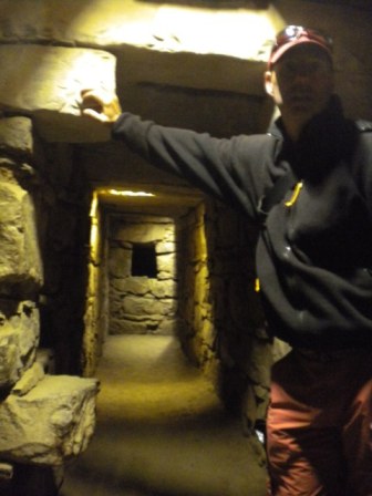
Next stop southward was the very nice and empty stretch of beach at Huanchaco where the fishermen use their reed boats - cabaillitos (little horses)- to fish the day away. There were some cool ruins nearby also at Chan chan et Huaca de la Luna.
Next stop southward was the very nice and empty stretch of beach at Huanchaco where the fishermen use their reed boats - cabaillitos (little horses)- to fish the day away. There were some cool ruins nearby also at Chan chan et Huaca de la Luna.
 |
| Chan Chan |
 |
| Chan Chan |
 |
| Chan Chan |
 |
| Huaca de la luna |
 |
| Huaca de la luna |
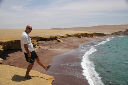
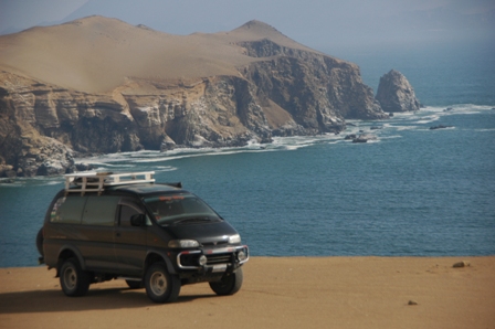
Encore plus au
sud, nous avons fait une boucle dans le parc national de Paracas. Très bel endroit,
toujours désertique …
And farther south still along the coast we took a 2-day off-road adventure (never been more off-road before) at the National Park of Paracas.
And farther south still along the coast we took a 2-day off-road adventure (never been more off-road before) at the National Park of Paracas.


Enfin, les mystérieuses
et énigmatiques lignes de Nazca, parait-il mondialement connues, de
gigantesques dessins dans le désert.
Nous n’avons pas trop été impressionnés. Il faut dire que pour avoir un
réel aperçu il aurait fallu qu’on se
paye un vol à 90 USD par personne hors de notre budget. Nous avons donc juste
gravi la tour métallique à moins de 1USD chacun, certes moins cher mais très décevant. Je cois que c'est supposé représenter un arbre.
Finally we pitched up at the 'observatory' for the Nasca lines. erm yes lines in the desert. Seems the only way to truly appreciate the lines is by a 90usd per person plane ride. Others say that the planes only make you sick. Who pays to get sick??? Not us. So we ponied up the 1USD to climb up a 4m tower and say awwwww. They say this is a tree. Sure it is.
Finally we pitched up at the 'observatory' for the Nasca lines. erm yes lines in the desert. Seems the only way to truly appreciate the lines is by a 90usd per person plane ride. Others say that the planes only make you sick. Who pays to get sick??? Not us. So we ponied up the 1USD to climb up a 4m tower and say awwwww. They say this is a tree. Sure it is.